 Original Oklahoma Route 4
 Original Oklahoma Route 4

Route Description from 1925 State Highway Map:
Beginning at the Kansas state line near Arkansas City, via Chilloco, Newkirk, Ponca City, Marland, Perry, Mulhall, Guthrie,
Edmond, Oklahoma City, Moore, Norman, Noble, Lexington, Purcell, Wayne, Paoli, Pauls Valley,
Wynnewood, Davis, Springer, Ardmore, Marietta, and Thackerville.
The original Oklahoma Highway 4 was the central north-south trunk line, traveling down almost the exact middle of the state. Along the way, it passed through oil fields, farmlands, and both the original and current state capitals. In addition to being the spine for the original state highway network, Route 4 was a heavily traveled connector between Dallas and Wichita. Like most of the other major original routes, its importance eventually led to its demise when Route 4 was overlaid by a US route in 1927. Nevertheless, we will as usual present an approximate alignment of original Route 4 on modern highways, as if the State Highway commission had been more stubborn and insisted on keeping their numbering system along with the federal system.

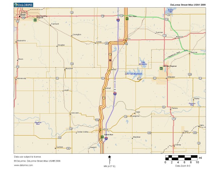
If the original Oklahoma Highway 4 existed today, it would begin at the Kansas state line on US Highway 77 just south of Arkansas City, KS. The highway would travel concurrent with US 77 to Ponca City, take the business loop through town, then rejoin the mainline before turning south onto modern State Highway 156 to pass through Marland. Route 4 would then rejoin US 77 and continue toward Perry. For information on the historic alignment of US 77 in this area, please see the US 77 Arkansas City to Perry detailed routes page.

After passing through Perry, a modern Route 4 would continue to travel together with US 77 toward Guthrie. After passing through the original state capital, Route 4 and US 77 merge onto I-35 for the run toward Edmond. For the historic route of US 77 in this area, see the US 77 Perry to Edmond page.

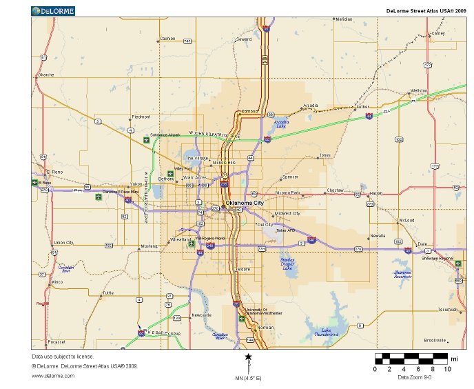
Route 4 continues with US 77, leaving the limited access expressway to pass through Edmond before rejoing the expressway system to travel through Oklahoma City. Route 4 and US 77 together slice through the center of the city before leaving the limited access again near Norman. For the old route through Oklahoma City, see the US 77 Oklahoma City page.

Modern Route 4 would remain concurrent with US 77 traveling south, crossing the Canadian River at Purcell and continuing south toward Pauls Valley and Wynnewood. For information on the historic route, see the forthcoming US 77 Moore to Wynnewood page.

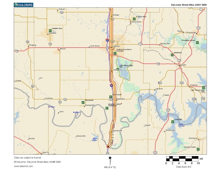
US 77 and Route 4 would continue south together, crossing over the Arbuckle Mountains between Davis and Springer before continuing on to Ardmore. The route in this area has not changed much since the early days of the highway, thus much of this road actually was Route 4.

From Ardmore, a modern Route 4 would remain concurrent with US 77 through Marietta and Thackerville before joining with I-35 and reaching its southern terminus at the Red River. For the historic route in this area, please see the (coming soon) US 77 Wynnewood to Texas page.
As should be evident by this point, the coming of US Route 77 in 1927 spelled the end for the original Oklahoma Route 4. The only place where the two highways diverge in the path we have just described, SH 156 through Marland, was US 77 in 1927. With the entire path of the highway being overlaid by a federal route number, it is easy to see why the OSHC decided to reuse the number elsewhere after 1930. Really, the numbering became obsolete because the commissioners identified the important routes so well in the first place; that US highways were overlaid on them is an affirmation of their importance, but unfortunately denied us the use of the original elegant numbering system. We hope you enjoyed this look at what could have been.
Back to 1925 State Routes 1 to 6 Index
Back to Main Page
Base Map Data Copyright DeLorme USA, http://www.delorme.com
State Highway Shields created by Ken Parker of Oklahoma Bridge & Highways Group.